The main objective is to organize the International Speleological Survey Camp TOPO SORBAS to get the topographic maps as detailed as possible to describe accurately the large speleological complex existing in the gypsum karst of Sorbas. Mainly, is to gain the new data to complete and expand the Sorbas Karst global topography.
The aim is to maximize the opportunities offered by new surveying technologies which are currently being developed, such as "Auriga", that is giving a lot of information in real time. Thanks to this, it's possible to obtain a general overview of the speleological network, while in meantime new parts of the cave are beeing measured.
The Sorbas gypsum karst is organized in ten different sectors. To facilitate their study each sector is divided into zones. Work will focus on the major sectors of the Karst, such as Viñicas Sector or Tesoro Norte sector, without ruling out the explorations in other nearby areas such as Rio Aguas sector or Hueli sector. Depending on the progress made, there could be planed activities in other sectors.
Essentially, the work areas in the International Speleological Survey Camp TOPO SORBAS can be distinguished into three sections:
- Specific work areas
- Threatened areas
- Large systems
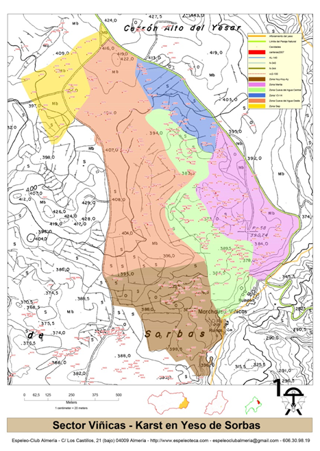
Figure 1. Distribution of cavities in the Viñicas Sector
Map 1. Sectors and areas within the Sorbas Gypsum Karst Ver mapa más grande
All the proposed areas where the activities will take place are represented in the following table, which contains also the total number of cavities of each zone and sector inventoried in the CatSORBAS. These data have been updated recently and are available to anyone who asks in www.espeleoteca.com, in the section CatSORBAS online.
The distribution of the different sectors within the gypsum karst is detailed in the following figure, where the different density of cavities is pointed too.
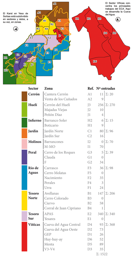
Figure 2. Distribution of sectors and areas within the Sorbas Gypsum Karst
Another detailed look at the density of cavities divided by sectors and areas is shown in the following table:
| Sector VIÑICAS | 368 |
| ZONA OESTE | 73 |
| ZONA CENTRAL | 93 |
| ZONA V3-V4 | 35 |
| ZONA MENTA | 89 |
| ZONA HUY HUY AY | 52 |
| ZONA GEP | 26 |
| sector TESORO SUR | 340 |
| ZONA APAS | 340 |
| Sector HUELI | 270 |
| ZONA DE LAS MAJADAS VIEJAS | 10 |
| ZONA DEL CERRÓN DEL HUELÍ | 256 |
| ZONA DEL PEÑÓN DÍAZ | 4 |
| Sector TESORO NORTE | 206 |
| ZONA DE LAS AVELLANAS | 147 |
| ZONA DEL CIERVO | 58 |
| ZONA DEL CORRAL DE JUAN CIPRIANO | 1 |
| Sector RÍO AGUAS | 98 |
| ZONA CARRASCO | 36 |
| ZONA DE LOS PERALES | 3 |
| ZONA NACIMIENTO | 35 |
| ZONA URRA | 24 |
| Sector MOLINOS | 70 |
| ZONA M – MO | 70 |
| Sector PERAL | 39 |
| ZONA DEL CERRO DE LOS ROQUES | 5 |
| ZONA F | 34 |
| Sector INFIERNO | 15 |
| ZONA BARRANCO SOLER | 6 |
| ZONA DEL BOTICARIO | 9 |
All obtained information will be organized and added to the CatSORBAS database, updating the data in online version of CatSORBAS also. In this way, the data will be integrated into the new Andalusian Caves and Canyons Catalog developed and implemented by the Andalusian Federation of Speleology, which is to be operational in a short time.
The following graphs visually represent actual data of the distribution and number of cavities by sectors and areas within the gypsum karst of Sorbas.
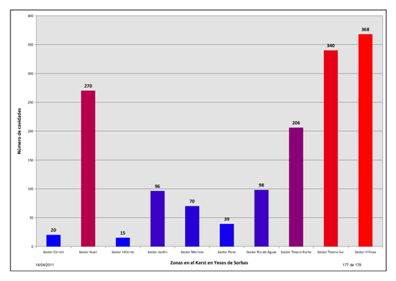
Graphics 1. Distribution of cavities by sectors
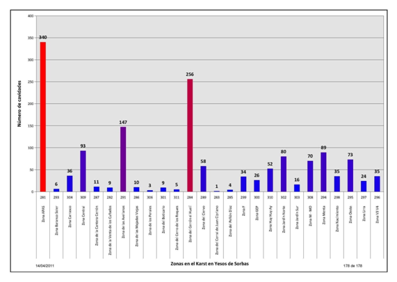
Graphics 2. Distribution of cavities by areas
